Korea on the Map (지리·기후): Geography, Climate & Regions
Where Korea sits in the world, what the land looks like, and how geography shaped everything that came after.
Korea is often described as a small country — but "small" doesn't tell the full story. It's a peninsula of dramatic contrasts: granite mountains dropping into quiet rice paddies, a jagged western coastline of tidal flats giving way to the deep clear waters of the east, and a capital city of 10 million people wedged between rivers and hills. The landscape is more varied than its size suggests, and it has shaped Korean culture in ways that are still visible today.
반도의 위치 (The Peninsula)
Korea occupies a peninsula that extends southward from the northeastern corner of the Asian continent. It shares land borders with China to the northwest and Russia to the northeast — though both borders are in North Korean territory and effectively unreachable from the South.
To the west lies the 서해 (Seohaes, Yellow Sea — called the West Sea by Koreans). To the east lies the 동해 (Donghae, East Sea — internationally often labeled the Sea of Japan, a naming dispute that remains politically sensitive). To the south, the 대한해협 (Korea Strait) separates the peninsula from Japan — the closest point between 부산 (Busan) and Fukuoka is just 200 kilometers apart.
The peninsula is divided roughly in half at the 38th parallel by the 비무장지대 (DMZ, Demilitarized Zone) — a 4-kilometer-wide strip of land that has separated North and South Korea since the armistice of 1953. 대한민국 (South Korea, the Republic of Korea) occupies the southern half.
Tip — 동해 vs. 일본해 (East Sea vs. Sea of Japan): Koreans feel strongly about using 동해 (East Sea) rather than 일본해 (Sea of Japan). On international maps, both names often appear. When speaking with Koreans, use East Sea — it carries historical weight related to the Japanese colonial period, not just geographical preference.
지형 (The Land)
산이 지배한다 (Mountains dominate). About 70% of South Korea's land is mountainous, with ranges running primarily north to south along the eastern side of the peninsula. The 태백산맥 (Taebaek Mountains) form the spine of the east coast; the 소백산맥 (Sobaek range) cuts diagonally across the south. The highest peak in South Korea — 한라산 (Hallasan) on 제주도 (Jeju Island) — rises to 1,950m. The highest peak on the peninsula proper is 설악산 (Seoraksan, 1,708m) in the northeast.
The consequence: most flat, arable land is concentrated in the west and south, and that's where most cities and agriculture developed. 서울 (Seoul) sits in a wide river basin in the northwest. The 호남평야 (Honam Plain) in the southwest has been Korea's rice basket for centuries.
강이 지역을 나눈다 (Rivers shape the regions). The 한강 (Han River) bisects Seoul and is arguably Korea's most iconic waterway — lined with parks, cycling paths, and a riverside culture that's become central to 서울 생활 (Seoul life). The 낙동강 (Nakdong River) runs the length of the southeast, passing through 대구 (Daegu) and emptying near 부산 (Busan). The 금강 (Geum River) flows through the center of the country.
해안선이 모두 다르다 (Three completely different coastlines). Korea has three distinct coasts:
서해 (West coast): Shallow, with massive 갯벌 (tidal flats) that can expose kilometers of mudflats at low tide. Rich in seafood, particularly 조개 (clams) and 꽃게 (crabs). The tidal range here is among the largest in the world
동해 (East coast): Deep, relatively straight, with clear water and white sand beaches. Popular for summer tourism. Sunrise over the East Sea is a Korean bucket-list experience
남해 (South coast): Heavily indented with a complex network of peninsulas and roughly 3,000 islands. 한려해상국립공원 (Hallyeohaesang National Park) is one of Korea's most scenic areas
제주도 (Jeju Island). South Korea has over 3,000 islands, most small and uninhabited. The largest and most significant is 제주도 (Jeju Island) — a volcanic island about 100km off the southern tip of the peninsula, with a subtropical climate, 용암동굴 (lava tubes), UNESCO World Heritage sites, and Korea's highest mountain. It functions as Korea's Hawaii: honeymoon destination, domestic tourism hub, and natural escape.
기후와 계절 (Climate and Seasons)
Korea has four distinct seasons — and Koreans are attached to them. Seasonal change is deeply embedded in 음식 (food), 의복 (clothing), and cultural practice.
The average temperature ranges from -6°C in winter to 25°C in summer — but those are averages. Depending on the region and the day, temperatures can drop below -20°C in winter and rise above 35°C in summer. The gap between the average and the extreme is wider than most visitors expect.
Season | Months | What to expect |
|---|---|---|
Spring | March–May | Mild and brief. Cherry blossoms typically peak in early April. One of the best times to visit. |
Summer | June–August | Hot, humid, and rainy. The monsoon (장마, jangma) brings weeks of rain in late June–July. August is often brutally hot. |
Autumn | September–November | Cool, dry, and spectacular. Foliage peaks in October–November. Many Koreans consider this the best season. |
Winter | December–February | Cold and dry, with significant snowfall in mountainous areas and the northeast. Seoul averages around -5°C in January. |
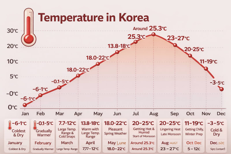
Tip — 장마 (The Monsoon Is Real): If you're visiting in late June or July, pack accordingly. The 장마 (jangma) brings sustained rain for 2–4 weeks, not just afternoon showers. August heat and humidity are intense — this is when Koreans eat 삼계탕 (samgyetang, ginseng chicken soup) to fight heat with heat, a practice called 이열치열 (以熱治熱, fighting heat with heat).
지역 (The Regions)
South Korea is divided into 17 administrative regions. In practice, most people think in terms of broader cultural regions with distinct characters.
수도권 (Capital Region)
서울 (Seoul), 인천 (Incheon), and 경기도 (Gyeonggi Province) together form a megalopolis of roughly 26 million people — about half the entire South Korean population. Political, economic, and cultural gravity is heavily concentrated here.
강원도 (Gangwon Province)
The mountainous northeast. Ski resorts (평창 Pyeongchang hosted the 2018 동계올림픽 Winter Olympics), national parks, and the clearest beaches on the east coast.
충청도 (Chungcheong Province)
The central region. Home to 세종 (Sejong), the planned administrative capital built to relieve Seoul's concentration. Also the location of 공주 (Gongju) and 부여 (Buyeo), ancient capitals of the 백제 (Baekje) kingdom.
경상도 (Gyeongsang Province)
The southeast. 부산 (Busan — Korea's second city and major port), 경주 (Gyeongju — the ancient Silla capital, essentially an open-air museum of Korean history), and 대구 (Daegu).
전라도 (Jeolla Province)
The southwest. Known throughout Korea for having the best 음식 (food) — 전주 (Jeonju) in particular is considered the culinary capital. Also the heartland of the progressive political tradition.
제주도 (Jeju Island)
Technically a special autonomous province. Culturally distinct — its own dialect, matriarchal diving tradition (해녀, haenyeo), and volcanic landscape. One of Korea's most visited domestic and international destinations.
Tip — 지역 정체성 (Regional Identity Matters): Koreans are aware of and sometimes proud of regional differences — in dialect, food, and political tendency. The rivalry between 경상도 (Gyeongsang — conservative-leaning, historically dominant) and 전라도 (Jeolla — progressive-leaning, historically marginalized) is one of the most persistent regional dynamics in Korean politics. You'll encounter these differences in conversation.
지리가 문화를 만든 방법 (How Geography Shaped Korea)
Korea's geography isn't just scenery — it explains things.
The mountains that cover 70% of the land meant that Koreans historically lived in relatively isolated valleys, developing strong local identities and a culture of community self-reliance. The same mountains that made agriculture difficult also made defense easier — Korea has repelled numerous invasions, though not all.
The peninsula's position between China and Japan created both a channel for cultural transmission (Buddhism, Confucianism, and writing systems all arrived through China) and a source of vulnerability. Japan colonized Korea from 1910–1945; the peninsula has been contested across centuries of East Asian history.
The concentration of half the population in the 수도권 (capital region) is a modern phenomenon — and a source of ongoing tension. Housing prices, education quality, and economic opportunity are disproportionately concentrated in Seoul, which drives internal migration and a cultural sense that everything important happens in one city.
Key Facts
면적 (Area) | 100,363 km² — roughly the size of Indiana, or slightly larger than Hungary |
지형 (Terrain) | 70% mountainous; flat land concentrated in the west and south |
최고봉 (Highest peak) | Hallasan (한라산), Jeju Island — 1,950m; highest peak on the peninsula proper: Seoraksan (설악산) 1,708m |
주요 강 (Major rivers) | Han (한강, Seoul) · Nakdong (낙동강, southeast) · Geum (금강, central) |
해안선 (Coastlines) | West: tidal flats (갯벌) · East: sand beaches · South: islands & rias |
섬 (Islands) | Over 3,000 — largest is Jeju Island (제주도) |
기온 (Temperature) | Average range -6°C to 25°C; extremes possible below -20°C in winter and above 35°C in summer depending on region and conditions |
장마 (Monsoon) | Heavy rainfall concentrated late June–July; sustained for 2–4 weeks |
수도권 인구 (Capital region population) | Approximately 26 million — roughly 50% of the entire national population |
행정 구역 (Administrative divisions) | 17 regions — 1 special city · 6 metropolitan cities · 1 special autonomous city · 8 provinces · 1 special autonomous province |
Help keep this content free for everyone.
Comments
Inappropriate comments may be deleted.
Log in to leave a comment.
No comments yet. Be the first!